
| 3-day forecast 10-day forecast | Smoke forecast | Avy forecast | |||
| Photo | Trail Name | Hike Date | Trail Status | Comment | Submitted By |
| Berg Lake Trail in Mt Robson Provincial Park, BC | 2026-Jan-10 | Snowshoe Packed | Kinney Lake trail is packed well enough to go just in boots until Kinney campground! Temps -3 to 0 midday today along the trail. Enjoy before the warmer temps soften the trail | ||
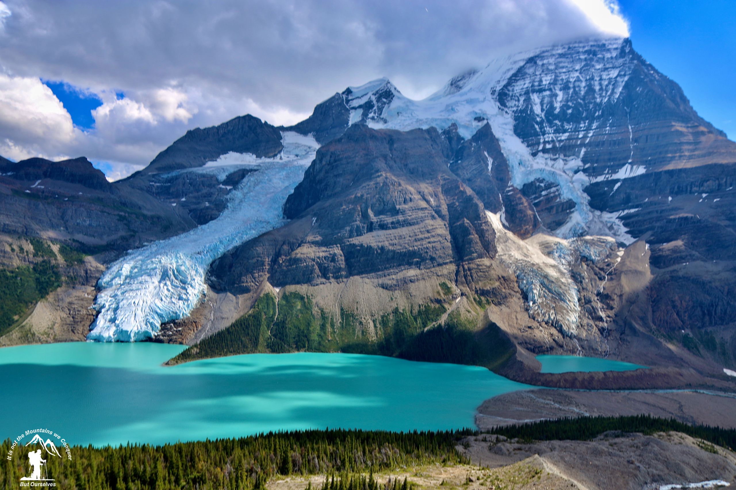
 | Berg Lake Trail in Mt Robson Provincial Park, BC | 2025-Jul-10 | Dry | I think there are lots of pictures of Berg lake trail, so I am just going to post the photos from Snowbird Pass and Mount Robson Glacier that I took recently - if you are taking the time to do the trail make sure you save a full day to do this, at 18km you need a spare day. Very weather dependent as the fog can extend out from the glacier and ruin the visibility and maybe make navigation back down difficult - but we got lucky this day - goats and all. | |
 | Berg Lake Trail in Mt Robson Provincial Park, BC | 2025-Jun-24 | Dry | The Berg Lake trail is clear of snow all the way. The snow line is already quite high for this time of year. | Mark Vejvoda |
This trail is about a 3-hour drive to the east (a 3-hour tour… a 3-hour tour) from Prince George BC. I snowshoed the Berg Lake trail to the north end of Whitehorn basin to the waterfalls by the old metal bridge that is no longer there as well as up close to Berg Lake itself! The trail is now open for winter, all the way to Berg Lake since the area is covered in ice and snow the summertime dangers are generally not an issue, though avalanches are definitely common here. There are numerous water sources but no cell signal in the area. This hike is world class offering incredible views, camping, and hiking possibilities, so make sure to check the BC Parks website for the latest information and closures: https://bcparks.ca/mount-robson-park/.
There are many options to consider when hiking this trail depending on your fitness level and the amount of time you have.
- Trailhead to Kinney Lake Bridge – approx. 4 km one way (elevation gain: 206 meters) [Easy]
- Kinney Lake Bridge to its camp – approx. 2.5 km more (total from trailhead is: 6.5 km one way) (elevation gain: 77 meters) [Easy]
- Kinney Lake camp to Whitehorn camp – 4 km more (total from trailhead is: 10.5 km one way) (elevation gain: 241 meters) [Moderate]
- Whitehorn camp to Emperor Falls – 3.5 km more (total from trailhead is: 14 km one way) (elevation gain: 469 meters) [Difficult]
- Emperor Falls to Berg Lake Marmot camp – 4.5 km more (total from trailhead is: 18.5 km one way) (elevation gain: 162 meters) [Easy]
- Berg Lake to Adolphus camp – 6.5 km more (total from trailhead is: 25 km one way) (elevation gain: 96 meters) [Moderate]
GaiGPS track: here
Directions to trailhead: here
Difficulty: Easy (to Kinney Lake) to Strenuous (to Berg Lake) depending on the distance traveled
Distance: 28.8 km
Ascent: 956 meters
Max elevation: 1642 meters
Moving Time: 7 hours 21 minutes
Total Time: 7 hours 39 minutes
Photos:


Videos:
December 2024:
March 2024:
December 2023:
December 2022:
March 2022:
April 2021:
Feb 2021:
August 2020:
Comments
Comments are closed.