
The First Peoples of this area, the Lheidli T’enneh, relied on rivers and lakes to travel through the dense forests of their territory. Some of these waterways were connected by overland trails later known as portages. One such trail is the shortest route between the waterways flowing to the Pacific Ocean and those flowing into the Arctic Ocean, which crosses over the Continental, or Arctic, Divide. This trail served as a highway for people travelling between territories to trade goods, gather food, and visit neighbours. The Lheidli T’enneh named this trail Lhdesti or “the shortcut.” The highest point of the trail is the boundary between two nations, the Lheidli T’enneh to the south and the Tse’Kenne to the north.
In the fall of 1862, John Robert Giscome, a prospector from Jamaica, and Henry McDame, another prospector from the Bahamas, met in Quesnel. The pair decided to go to the Peace River area after hearing that gold had been found in the Finlay and Parsnip rivers. The two left Quesnel in November, reaching Fort George on November 24, 1862. The two men had originally planned to travel to Fort St. James via Fort George, enter into Stuart Lake, and then cross over a section of the Hudson Bay Company Brigade Trail to Fort McLeod. From there, they would continue north using the rivers to eventually connect to the Peace River. However, by the time they arrived, the rivers had begun to freeze up, and they decided to spend the winter in Fort George instead of at Fort St. James.
During their stay in Fort George, they met several Indigenous people trading at the Hudson’s Bay post. They told Giscome and McDame of an alternate route to McLeod Lake via the Salmon River, a tributary of the Fraser River located 18 miles north of Fort George. This route involved a short portage from the upper Salmon to Summit Lake, where they could continue north.
Accompanied by a First Nations guide from Fort George, the three set out in April of 1863 and travelled by canoe up the Fraser River. Held up by ice for approximately eight days, they were disappointed to find that upon reaching the Salmon River, further travel would be impossible, as the water level was very high. However, their guide suggested another route further up the Fraser River that would involve a portage of about nine miles, or 14.5 kilometres. Once over the portage, the men travelled various lakes and streams to reach Fort McLeod. “A salute of about 30 shots was fired, with firearms, in honour of the arrival of the party through a route that was seldom used.
In December of 1863, when Giscome had returned from the north, he wrote a letter that was published in The Daily British Colonist, a Victoria newspaper. In the article, the story of Giscome’s journey is recounted, which included his trek over the Continental Divide shown to him by the guide. It is due to this article that the trail became known as Giscome Portage.
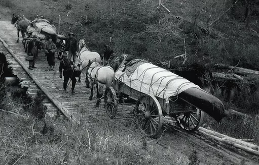
Despite the article, the trail saw little non-Indigenous use until the Omineca Gold Rush. Despite gold being discovered in 1861, the rush did not truly begin until 1869, after a discovery at Vital Creek. Traffic increased as prospectors crossed over the portage to the Omineca River. In 1871, British Columbia miners petitioned the government, demanding a “wagon road across the Giscome Portage” to ease access to the Omineca gold deposits. Work on the road began in May of the same year, and despite complications, it was finished by the end of July, with a total length of “seven miles and twenty-four chains” (approximately 11.75 km) and a width of “twelve feet for the first three miles from the Fraser River, then ten feet from Tay Creek to Summit Lake.”
Though the Portage saw frequent use by both miners and government officials, there was little or no permanent settlement in the area prior to the turn of the century. By the 1890s, traffic on the portage subsided as miners left for new gold strikes and other transport routes gained popularity. The road fell into disrepair until it was re-cleared by Seebach and Huble in the early 1900s. The business partners used it to freight goods over the portage with a horse and wagon. However, use would decline again by 1918, by which time the railroad had gone in across the river, and a wagon road was built that connected Prince George to Summit Lake. Today, the Giscome Portage is a popular destination for those wanting to walk through history. The trail today is approximately 8.5 km long.
Full history and details can be viewed at the Huble Homestead here
Photos:

