
| 3-day forecast 10-day forecast | Smoke forecast | Avy forecast | |||
| Photo | Trail Name | Hike Date | Trail Status | Comment | Submitted By |
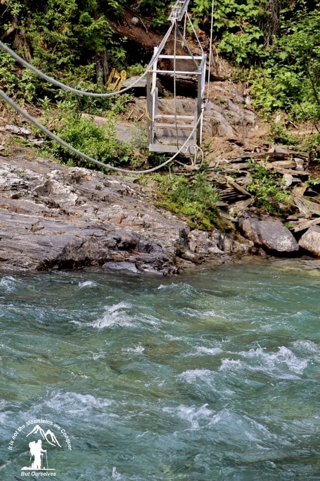
| Goat River Trail in Northern BC | 2025-Jul-01 | Dry | Goat River Cablecar Camping trip | ||
 | Goat River Trail in Northern BC | 2025-May-15 | Variable | We hiked the first 10 km of the Goat River Trail starting at the Goat River Forest Service Road, what an Epic trail this is! This part of the trail is about 36 km leading from the Goat River FSR to Bowron Lakes Provincial Park, trail conditions were clear of snow with some muddy sections. There was very little blowdown for the first 10 km but a few large trees south of the cable car crossing. | Mark Vejvoda |
Historic hiking route along the Goat River leads to Bowron Park and Barkerville.
Trail Description
The Goat River Trail consists of two distinct recreation trails, separated by about 8 km of the Goat River Forest Service Road. Each trail uses major portions of the Historic Goat River Trail and both are sections of the National Hiking Trail.
The Upper and Lower Goat River Trails are two distinct recreation trails separated by about 8km of the Goat River Forest Service Road. Each trail uses major portions of the Historic Goat River Trail and both are sections of the National Hiking Trail.
Lower Goat River Trail: Crescent Spur to Kopas Camp (14 km; 1 day)
This trail makes an excellent day hike. Beginning at the Crescent Spur Trailhead, hikers pass through rare interior old-growth rainforest with western red cedar trees as much as three metres in diameter. The trail crosses the Goat River on the Highway 16 bridge, about 11 km from the Crescent Spur trailhead enroute to Kopas Camp, located in an old logging block.
Upper Goat River Trail: Goat-Milk confluence to Littlefield Creek (49 km; 3-5 days)
Traversing the pristine wilderness of the upper Goat River Valley, this segment is the most remote and spectacular portion of the trail. Hikers can camp on gravel bars along the river, but are subject to being flooded in high water. A few sites established on higher ground have bear caches with hoisting cables and pit toilets. After crossing a logging bridge over the Milk River, the trail follows the Goat River upstream for 4 km, where a cable car ferries hikers across the river. Use the cable car at your own risk; it is potentially hazardous, particularly to fingers that may be pinched by pulleys. An alternative crossing is a horse ford about ½ km upstream. Whitehorse Creek, 1.3 km from the crossing is the first of many fords hikers will encounter. Exercise extreme caution at all stream crossings. The next major crossing is Macleod Creek, about 14 km from the Milk River trailhead and the most difficult and dangerous ford of the hike. Note that in high water from Spring runoff or heavy rain, it may not be possible to ford the creek. Near the ford, the trail passes the ruins of a cabin built prior to 1912. Another 9 km brings hikers to a knee-deep ford at Summit Creek. The trail then leaves the Goat River, heading 2.2 km west to Wolverine Pass between the Goat and Wolverine Rivers, where the trail enters Bowron Lake Provincial Park. Cushman Camp (named for the local outfitter) is situated in a large avalanche path with ample room for group camping 2.1 km from the pass. More detail is available on the FHA website, www.fraserheadwaters.org, or from the Central Interior Trail Guide, Vol. 1- Prince George and Region. From here, the trail follows the Wolverine River for 3.9 km before climbing steeply into an old logging block. Up to this point the trail has followed the Historic Goat River Trail. Deactivated logging roads are utilized from here on. A potential campsite can be found within the first block, just before fording Rockbed Creek. Another 3 km and hikers are rewarded with a spectacular view of Isaac Lake on the Bowron Lake chain, before the trail turns and descends to Littlefield Creek. After following Littlefield Creek for 14 km and fording it three times (challenging when flows are high), hikers reach the trailhead at the junction of the Littlefield Creek Forest Service Road and the Kruger Lake Road. From the trailhead, Wolverine Mountain Outfitters is 3.1 km along a two-wheel drive road.
History
Although the route was probably used by First Nations, pre-contact, the Goat River Trail’s known history began with a crew in the summer of 1886, working for John Bowron, Gold Commissioner of the Cariboo. It was led by Robert Buchanan and included George Isaacs, Arthur Johnston, Kenneth McLeod, and Neil Wilson, all of whom were noted namesakes in the Barkerville and Bowron area. It is documented in a report published in the 1886 Minister of Mines Report. They were tasked with finding a route to the upper Fraser River from the Barkerville goldfields, marking the trail, and exploring for gold prospects along the way.
Access:
Lower Goat: Approximately 50 km west of McBride (160 km east of Prince George) on Highway 16, turn north on Loos Road to Crescent Spur, then right on Prospect Road to its end where the trailhead is located. It can also be accessed from the Goat River rest area on Highway 16 where the trail crosses the river on the highway bridge, or from Kopas Camp at 5 km on the Goat River Forest Service Road. Upper Goat: The eastern trailhead is located at a right fork at kilometer 13 on the Goat River Forest Service Road (37 km west of McBride or 175 km east of Prince George on Highway 16). The western trailhead, 50 km northeast of Barkerville, can be accessed by driving to Bowron Lake Park Headquarters and following the signs 21 km to Wolverine Mountain Outfitters on Kruger Lake Road. The trail begins at Littlefield Creek, 3.1 km past the outfitter’s residence.
How to get there:
Both ends of the trail are accessible by car. Regional airlines connect Prince George and Quesnel with major cities. Via Rail’s Skeena will drop hikers at the eastern trailhead if they ask the conductor to be let off at Crescent Spur, Mile 32. Nearest Towns: The villages of McBride and Wells offer a variety of amenities, including hotels and restaurants. Hiking equipment and supplies can be purchased in Prince George, Jasper, Williams Lake, or Quesnel, and to a lesser extent in McBride and Valemount.
Accommodation:
Wolverine Mountain Outfitters, located near the Littlefield Creek trailhead, occasionally rents rustic cabins on the shore of Kruger
Lake. As well, there are three commercial lodges at Bowron Lake: Beckers Lodge, Bear River Merchantile, and Bowron Lake Lodge.
Bowron Lake Provincial Park offers tent and RV camping. At the eastern end, a wilderness resort offers private accommodations
about 2 km from the Crescent Spur trailhead.
Safety:
The Goat River Valley is a wilderness area and access to emergency services is extremely limited. Hikers must be self-sufficient and prepared for inclement mountain weather at all times of the year. Several fords are required in the Upper Goat, and hikers should exercise extreme caution at high water levels. As this is bear country, hikers should educate themselves on bear safety and
practice bear-safe camping to avoid confrontations. Use caution on Forest Service Roads: drive slowly.
Links related to this historic trail:
facebook page facebook discussion here
Useful Contacts
Wolverine Mountain Outfitters (250) 747-0766
Becker’s Lodge www.beckerslodge.ca (250) 992-8864
Bowron Lake Lodge www.bowronlakelodge.com
Bear River Mercantile www.bowronlake.com (604) 424-4330
Canadian Country Cabins www.canadiancountrycabins.com
VIA Rail www.viarail.ca (888) 842-7245
Bowron Lake Provincial Park
www.env.gov.bc.ca/bcparks/explore/parkpgs/bowron_lk/
BC Forest Service, McBride (250) 569-3760
Village of McBride (250) 569-2229
For more information:
Fraser Headwaters Alliance
6005 Brown Road, Dunster, BC, V0J 1J0
(250) 968-4410 (fax: 4410)
www.fraserheadwaters.org
GPX track: here
Distance: 4.33 km
Elevation Gain: 0 m
Elevation Loss: 0 m
Elevation Max: 0 m
Elevation Min: 0 m
Photos:


Videos:
May 2025: