
‘Driscoll Ridge’ is the informal name that Mike Nash gave this area many years ago when, in 1988, he first began exploring what is now the Ancient Forest / Chun T’oh Whudujut Provincial Park. Stretching roughly ten kilometres along the south side of Highway 16, about an hour’s drive east of the City of Prince George, Driscoll Ridge climbs for more than a vertical kilometre through three biogeoclimatic zones. The Interior Cedar-Hemlock zone starts just below the highway elevation and is home to the ancient Western Red Cedar forests that are the main feature of Driscoll Ridge. Above the ICH is the Engelmann Spruce-Subalpine Fir biogeoclimatic zone, and above that is a limited Alpine Tundra zone. For some 15 years, Mike bushwhacked-explored the ridge on foot in the summer and fall months, and on backcountry skis in the winter.


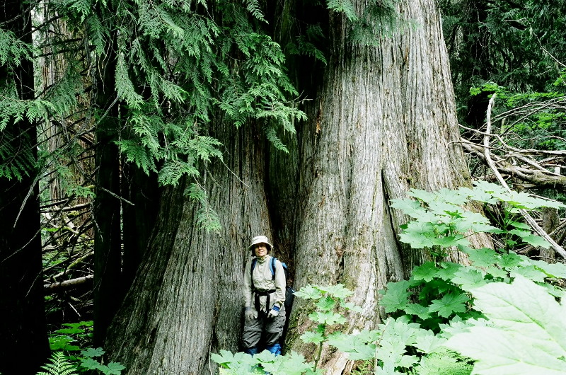
Driscoll Ridge is notable for two reasons: the lower elevations are home to perhaps the best representation of inland temperate rainforest left in the world, while the ridgetop offers excellent mountain views. Driscoll Ridge is isolated from the surrounding mountain ranges, but this same isolation affords a unique vantage of the surrounding Rocky and Columbia Mountains. Driscoll Ridge is relatively close to Prince George and, like the nearby Sugarbowl-Grizzly Den Provincial Park, has year-round highway access.
After his initial solo explorations in the late 1980s, Mike led groups off-trail on Driscoll Ridge. While hiking club trips focused on the higher elevations, naturalists explored the lower elevation ancient forests. It was on one of these in 2001 that UNBC’s Dr Darwyn Coxson drew our attention to the significance of the antique forests and their rich lichen communities. Subsequent work by UNBC students identified many ancient trees and spotlighted the globally rich and unique lichen and plant communities. This in turn led the nearby community of Dome Creek to work to protect the ancient trees from further logging for their ecological, interpretive and recreational values. Through the efforts of that community, a trail was roughed in, a documentary film, Block 486, was made, and a successful complaint was made to BC’s Forest Practices Board. BC’s Chief Forester, while increasing the annual allowable cut of Mountain Pine Beetle killed timber, simultaneously reduced the cut in the ICH in recognition of its values and citizen concerns. This led, in the early 2000’s, to a project to establish spatially fixed Old Growth Management Areas, in response to which Mike submitted maps of all the high-value old growth that he had discovered along the lower slopes of Driscoll Ridge during his years of exploration. Most of these recommendations were accepted, and the resulting OGMAs afforded the first real protection for the ‘Ancient Forests’ of Driscoll Ridge.
In 1990, Mike submitted a written proposal to the Ministry of Forests (MOF) for recreational trails on both Driscoll Ridge and at the nearby Grand Canyon of the Fraser, the first such for either of these future parks. While nothing came of that first Driscoll proposal, the Grand Canyon proposal elicited a definite ‘No.’ That spurred him to submit a more in-depth proposal for the Grand Canyon to the then Regional Director for BC Parks, resulting in an immediate ‘Use, Recreation and Enjoyment for the Public’ designation being placed on it that would later ease the way for the Grand Canyon to be included in the new Sugarbowl-Grizzly Den Provincial Park in the late 1990s.
Michael Nash,
Prince George, BC
24th April 1990
Ministry of Forests,
Prince George District,
2000, South Ospika Blvd.,
Prince George, BC, V2N 4W2.
Re: Fraser Valley Recreational Trail Proposals
Further to our telephone conversation today, I am enclosing tentative trail locations for the two Highway 16-accessed recreational hiking projects which I am proposing.
Driscoll Mountain can be completed at relatively low cost, since much of the route exists by means of an old logging access road at the bottom, and well-established game trails higher up. The alpine is limited, but there are three or four kilometres of very nice ridge walking, with unsurpassed 360-degree views on a clear day, and a small destination alpine lake.
Views include: Boulder Mountain, Erg Mountain, Dome Mountain, Slim Lookout, Vineyards, Caledonia Mountain (one of its best views), Tumuch Lake and Ridge, Grizzly Den, Raven Lake, Viking Ridge, Sugarbowl Mountain, the Fraser Rift Valley (one of the best East/West views), Bearpaw Ridge, Red Mountain/Penny, Rocky Mountains (including Mt. Sir Alexander – one of the few locations in the Fraser corridor where it can be seen almost down to Highway elevation). In short, this viewpoint ties together all of the mountain hiking areas East of Prince George better than any other that I know. It is relatively close to Prince George, and of course, has valued highway access.
The main drawbacks are:
1. It is of limited interest in poor weather, as with most of our mountain trails.
2. It has limited alpine, but there’s enough for a day trip. The summit is reached sooner than on some comparable mountains, putting it within reach of more people who might otherwise only make it to a ridgeline, such as on Sugarbowl.
3. The existing access requires heavy bushwhacking through Devils Club at lower elevations, but the trail will hopefully take care of this.
The Grand Canyon of the Fraser is of great historical and scenic interest, and could be a superb addition to the area. (Photograph enclosed). It would be longer than the very successful Fort George Canyon trail, but the rewards are greater, and I believe it would be equally popular. The trail would be more expensive to build than Driscoll, since, as a low-elevation destination trail, it will be more heavily used and will require a similar standard to the Fort George Canyon trail. The route is in place almost to the river via an old forest road. Kenneth Creek would require a footbridge near its confluence with Sugarbowl Creek, but there are two sets of old bridge pilings still in place. The project could be done in two phases:
1. to the river: 4 km (low cost; early completion)
2. along the river to the canyon: 3-4 km (higher cost; requires careful trail location; longer term completion)
With these two proposed trails (both with Highway 16 access) and with the existing Viking, Sugarbowl, Grizzly Den and Raven Lake trails nearby, the Fraser Valley East of Prince George could become a centre of hiking second to none in the Province, and at a relatively small development and maintenance cost.
I have explored the Grand Canyon twice on skis via different routes, and I have ascended Driscoll Mountain six times, three on skis, and three bushwhacking in summer. I would be pleased to provide any additional information and help in the trial location. As we discussed on the phone, I may do some initial layout on Driscoll this summer, but the route is fairly well established as it climbs a natural ridge line.
Yours sincerely
Michael Nash
In September 2005, Mike led a party of four on a bushwhack ascent of West Driscoll Ridge, a report of which appeared in the 2006 Canadian Alpine Journal titled ‘Drama on Driscoll.’ It was on the descent that he asked fellow hiking club member, Nowell Senior, if he would like to submit a proposal to the Ministry of Forests for approval of a mountain trail there. The club had a long history of working with MOF staff, and jurisdiction for forest recreation was about to change to a new agency. Nowell not only ran with that idea, but he expanded it to lead the construction of mountain trails on both the east and west ends of the ridge with a connecting trail on top. Then, building on his professional background in special needs, he undertook to build what became the universal (accessible) boardwalk that, today, is the focus of mainstream public use of the park. Nowell involved many individuals, businesses and organisations in what became a huge volunteer community effort, and today the boardwalk is named in his honour.
One of the key people to help build the boardwalk was long-term hiking club trails guru, Dave King. More importantly, Dave, Nowell and UNBC’s Darwyn Coxson combined their expertise to work on a proposal for what eventually became the Ancient Forest / Chun T’oh Whudujut Provincial Park. The park’s dual name recognises and is part of reconciliation with First Nations in whose traditional territory Driscoll Ridge lies.
A recording below by Art Carson of Valemount shows Mike Nash narrating on the top of Driscoll Ridge in 2006: